
From Indian land to City Suburb (1850-1900)
Up through the Pikes Peak gold rush of the 1850’s, the Congress Park area was Native American land. By 1860 the young city of Denver had grown to a population of 5,000, with six men to every woman. As the first stagecoaches were arriving in Denver in the late 1850’s, William Larimer, one of the city’s founders, sited the park-like Mount Prospect Cemetery on a prominent hill to reinforce the image of Denver as a refined city. The area the cemetery encompassed evolved over the next 100 years into the present-day Cheesman Park, the Morgan Addition, Denver Botanic Gardens, the Denver Waterboard Reservoirs, and Congress Park, for which our neighborhood is named. The coming of the railroad through Denver in 1870 paralleled another sudden surge in growth. Between 1880 and 1890 the city’s population boomed from over 35,000 to nearly 107,000. Through the 1880’s Denver’s air was so polluted because of unpaved roads, coal and wood furnaces, smelting and other industries that wealthy residents looked to the outskirts of Denver, such as Capitol Hill, for cleaner air and reclaimed mountain views. With the expansion of public transit, including cable cars, to Colfax Avenue in the late 1880’s and early 1890’s, the eastern reaches of Capitol Hill became more accessible to the middle class. Because Colfax was the main route downtown, homes were first built along its corridor to the north (now City Park South neighborhood) and to the south (now Congress Park neighborhood). This house was located at 2839 E. Colfax Between 1887 and 1888, our neighborhood was completely platted into more than ten subdivisions of various sizes. On March 11, 1889, the area was incorporated into Denver as part of a larger annexation by the city. It was also in the late 1880’s and early 1890’s that many of the street names in the neighborhood were renamed eg., Charles to Garfield, Cleveland to Fillmore to simplify and avoid duplicate street names which were causing confusion for the expanding city utility and emergency services.
“Capitol Heights” Grows with Plentiful Water, Improved Streets, Major Building and New Park Land
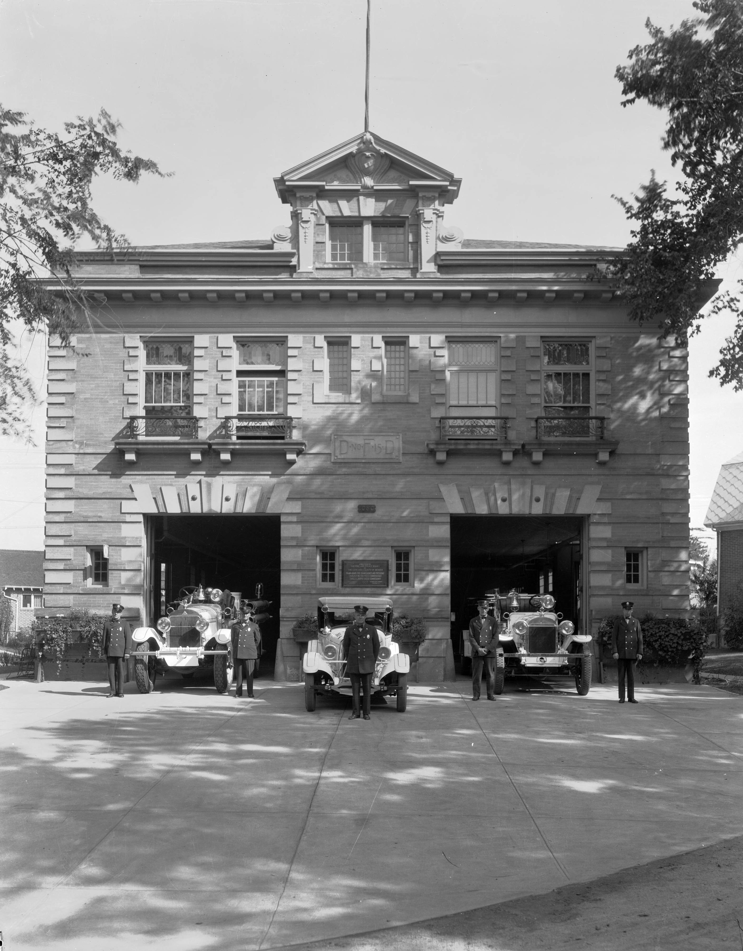
The area bounded by York, Colorado, 6th and 17th was generally referred to as Capitol Heights because of its proximity to Capitol Hill’s 5,400 foot high point, “Cemetery Hill.” Today this site houses the Water Board reservoir and Denver’s Communications Center forth of Congress Park. This picture of the pump station was taken in the 1930’s The Capitol Heights Presbyterian Church, Capitol Heights Pharmacy and other entities in the neighborhood still celebrate this old reference. The name “Congress Park Neighborhood” was introduced by the Denver Planning Office in the 1970’s for planning purposes. By 1890, Denver’s population had grown to nearly 107,000. To encourage and support an expanding Capitol Hill, a reservoir was built on “Cemetery Hill” in 1887, using gravity rather than the unreliable pumps of the day to bring water to residents below. Congress Park neighborhood developed primarily between 1890 and 1924, despite a temporary setback from the 1893 silver crash. Congress Park itself took its name from the way it was created. “City Cemetery” located on “Cemetery Hill” had become an unkempt eyesore and a deterrent to prospective residential development in east Capitol Hill. In 1890 Colorado Senator Henry M. Teller persuaded Congress that land previously sold to the City for burial purposes “in perpetuity” should be re-designated as a park. His bill passed, and as graves were relocated, a park was born. Only 10 acres of the original Congress Park remain. Other acreage became Cheesman Park, the Morgan Addition, Denver Botanic Gardens, and Denver Water Board land. Present day Congress Park south of the reservoir to 8th Avenue (formerly Bowles Avenue) was a dry wasteland. It had been part of the original cemetery, but never used as such. Easily irrigated by the reservoirs directly north of it, in 1903 the area was designated the City Nursery to supply the flowers and trees for Denver’s new legacy of parks and parkways. The Denver Union Water Company built the second (eastern) reservoir on Cemetery Hill in 1906. The site’s name was changed to Capitol Hill Clear Water Reservoir to dispel negative connotations with the former intended land use. By the time the streets were improved in the neighborhood to the north and east of the City Nursery and reservoirs in 1908, the population of Denver was nearly 213,000. With City Cemetery gone and reservoirs built, residential developments in Capitol Heights flourished. Among them, Snell’s Subdivision, a neighborhood Historic District including Colfax A and B between Madison and Cook, was resubdivided in 1903 by Frank S. Snell. His building sites led to uniquely more affordable housing near downtown and eliminated typically unsightly backyards. Many beautiful buildings that still grace our neighborhood were built during this turn-of-the century period. In 1900, George W. Clayton School (later Stevens School) opened. Stevens School at the 1100 block of Elizabeth, was converted into condos in 1994 and is a historically designated landmark. The old fire station #15 at the southeast corner of 11th and Clayton was built in 1903 on a northwest angle facing the neighborhoods it would serve. Now subdivided into two family residences, it is a Denver Historic Landmark. In 1911, the York Street Presbyterian Church relocated from the southeast corner of 13th and York to its new home, Capital Heights Presbyterian Church located at 11th and Fillmore. It was the first institution to incorporate the name Capitol Heights.
Schools, Recreation, Streetcars and Cars (1910-1940)
Near the end of World War I, Congress Park neighborhood children began to overflow Stevens School’s capacity. Teller Elementary was built in 1920 to handle the burgeoning student population. The old Gove Elementary on 13th & Harrison had already been converted to one of the city’s first junior high schools in 1917. City Nursery, located since 1903 on the grounds we know as Congress Park, boasted the largest victory gardens in Denver during WWI and into the 1920’s. In 1927, the Young America League organized football and baseball games for elementary and junior high youth on that site. The federal WPA program (Works Progress Administration) cleared and graded the field areas, built the terraced walls and planted trees during the 1920’s. Horse-drawn streetcars carried downtown commuters home to Congress Park neighborhood on tracks laid along 12th Avenue. Around streetcar stops, small commercial centers flourished, still present at 12th and Clayton/Elizabeth and 12th and Madison. At one time “Madison Square” enjoyed three competing groceries, a barber shop, a drug store/soda fountain, a filling station and a cafe. As technology advanced, horse-drawn cars were replaced with streetcars powered by overhead electric lines. This house belonged to Anne Evans and was located at 12th and Clayton. Anne Evans was a pioneer in Denver’s cultural institutions. By the late 1930’s, streetcar business began to suffer as automobiles became more affordable and popular. Detached garages were constructed along the alleys of existing homes, and garages were included in building plans for new homes beginning in the 1920’s. In 1940, pneumatic-tired trolley coaches were introduced. Route 13, which ran along 12th Avenue in Capitol Heights, was one of the first converted from streetcar to electric bus. These coaches ran in the area for 16 more years before a fleet of diesel buses was introduced in 1956.
Congress Park and “Signal Hill” (1940-present)
Ceremoniously dedicated as “Victory Park” in 1943, the neighborhood’s community gardens were declared by Mayor Stapleton to be “the most important community project we have yet undertaken.” Less than three years later, nearby residents decried the community gardens as “a nuisance and an eyesore”. By 1949, after losing a lawsuit filed by the neighbors, the city was forced to embark on is first major effort to landscape the neighborhood’s park and to rename it Congress Park in tribute to the original, much larger Congress Park created by a Congressional Act in the late 1800’s. The city’s proposal included a swimming pool which, due to six years of neighborhood controversy, was not built until 1955. Denver’s population had grown to over 415,000 when it opened. The park remains an active recreational complement to passive Cheesman Park for the greater Capitol Hill community. “Signal Hill”, the area directly north of the park, began developing in 1939 as the heart of Denver’s emergency alert system. In 1993, 54 years later, the candy-striped smokestack that was Congress Park’s landmark was demolished and the facility expanded into the City and County of Denver Combined Communications Center. Just as its appeal was in the beginning, as a streetcar suburb for the middle-class, Congress Park neighborhood remains a stable, residential community for those attracted to city life, parks, neighborhood shopping and quiet, tree lined streets. Go here for additional info Creating Communities, Denver Public Library, Congress Park
![]()

The house at 2839 E. Colfax was owned by my great great great grandfather, Finis Ernest.
Incredible! Thanks for sharing that information. It was an beautiful house
Enjoyed the article. Grew up at 5th and Columbine 1950 to 1963, attended the old Bromwell Elementary School, Hill jr. high, and East High. Learned to swim at the very, very cold waters of Congress Park Pool in 1955.